Maps and Plans: Difference between revisions
Geoff Blyth (talk | contribs) |
Geoff Blyth (talk | contribs) |
||
| (14 intermediate revisions by 4 users not shown) | |||
| Line 1: | Line 1: | ||
=Railway Maps and Plans - Europe | =Railway Maps and Plans - Europe= | ||
Many of the railway layout maps and plans on this page were drawn by Rodger Wilkinson of Chester-le-Street and Gregory Beecroft of Welwyn Garden City. These maps were formerly hosted on the 'Rinbad' website, but have been moved with permission. | Many of the railway layout maps and plans on this page were drawn by Rodger Wilkinson of Chester-le-Street and Gregory Beecroft of Welwyn Garden City. These maps were formerly hosted on the 'Rinbad' website, but have been moved with permission. | ||
| Line 6: | Line 6: | ||
Please remember that the maps were current at the dates when they were created but may have been overtaken by subsequent events. | Please remember that the maps were current at the dates when they were created but may have been overtaken by subsequent events. | ||
Maps and plans for countries beyond Europe are now held at the Enthusiast's Guide to Travelling the Railways of the Rest of the World - see the relevant [https://www.egtrow.info/wiki/Category:Maps_and_Plans EGTROW page] | |||
==Australia== | ==Australia== | ||
See [https://www.egtrow.info/wiki/Australia_-_Maps_and_Plans EGTROW] | |||
<!-- | |||
<gallery> | <gallery> | ||
Image:Brisbane1.pdf|Brisbane I | Image:Brisbane1.pdf|Brisbane I | ||
Image:Brisbane2.pdf|Brisbane II | Image:Brisbane2.pdf|Brisbane II | ||
</gallery> | </gallery> | ||
--> | |||
==Austria== | ==Austria== | ||
<gallery> | <gallery> | ||
Image:Linz.png|Linz | Image:Linz.png|Linz | ||
| Line 33: | Line 36: | ||
==Belarus== | ==Belarus== | ||
<gallery> | <gallery> | ||
Image:Minsk.png|Minsk | Image:Minsk.png|Minsk | ||
| Line 40: | Line 42: | ||
==Belgium== | ==Belgium== | ||
<gallery> | <gallery> | ||
Image:South of Berchem.jpg|Area south of Berchem | Image:South of Berchem.jpg|Area south of Berchem | ||
| Line 46: | Line 47: | ||
Image:Brussels North.png|Brussels North | Image:Brussels North.png|Brussels North | ||
Image:Brussels South.png|Brussels South | Image:Brussels South.png|Brussels South | ||
Image:Gent | Image:Gent Sint Pieters to Y Assels.jpg|Gent-Sint-Pieters - Drongen (Y Assels) | ||
Image:Montzen.png|Tongeren - Visé Haut - Montzen - Aachen (Germany) | Image:Montzen.png|Tongeren - Visé Haut - Montzen - Aachen (Germany) | ||
Image:Ottignies.jpg|Ottignies | Image:Ottignies.jpg|Ottignies | ||
| Line 54: | Line 55: | ||
==Bosnia-Herzegovina== | ==Bosnia-Herzegovina== | ||
<gallery> | <gallery> | ||
Image:Sarajevo.png|Sarajevo | Image:Sarajevo.png|Sarajevo | ||
| Line 63: | Line 63: | ||
==Bulgaria== | ==Bulgaria== | ||
<gallery> | <gallery> | ||
Image:Sofia East.png|Sofia East | Image:Sofia East.png|Sofia East | ||
| Line 70: | Line 69: | ||
==Croatia== | ==Croatia== | ||
<gallery> | <gallery> | ||
Image:Pula.png|Pula | Image:Pula.png|Pula | ||
| Line 77: | Line 75: | ||
==Czech Republic== | ==Czech Republic== | ||
<gallery> | <gallery> | ||
Image:Bohumin_area.png|Bohumin area | |||
Image:Brno.png|Brno as at July 2017 | Image:Brno.png|Brno as at July 2017 | ||
Image:Ceska Trebova.jpg|Česká Třebová goods lines | Image:Ceska Trebova.jpg|Česká Třebová goods lines | ||
| Line 95: | Line 93: | ||
Image:Nordhavn.png|Nordhavn | Image:Nordhavn.png|Nordhavn | ||
Image:Kobenhavn avoiding line.jpg|København avoiding line | Image:Kobenhavn avoiding line.jpg|København avoiding line | ||
Image:Koge_Nord_to_Olby.png|Køge Nord to Ølby | |||
</gallery> | </gallery> | ||
==France== | ==France== | ||
<gallery> | <gallery> | ||
Image:LGV Nord.png|LGV Nord diagramatic map | |||
Image:LGV Est.png|LGV Est diagramatic map | |||
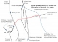
Image:Lille 5.jpg|Lille Flandres avoiding line - Raccordement de Becquerel | |||
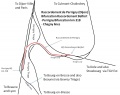
Image:LGVEst2.jpg|LGV Est - Raccordement de Lucy | |||
Image:Sarrebourg avoiding line.png|Sarrebourg avoiding line | |||
Image:Sarrebourg Area.png|Sarrebourg Area | Image:Sarrebourg Area.png|Sarrebourg Area | ||
Image:Les Saules.jpg|LGV Sud-Est - Raccordement de Valenton | |||
Image:Massy-Palaiseau.jpg|LGV Sud-Ouest - Massy TGV | |||
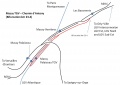
Image:Sable sur Sarthe triangle.png|LGV Bretagne-Pays de la Loire - Sablé-sur-Sarthe Triangle | |||
Image:Dijon.jpg|Dijon | Image:Dijon.jpg|Dijon | ||
Image:Tours4.jpg|Tours & St Pierre des Corps | Image:Tours4.jpg|Tours & St Pierre des Corps | ||
Image:Tours5.jpg|Tours & St Pierre des Corps | Image:Tours5.jpg|Tours & St Pierre des Corps | ||
Image:Culoz.png|Culoz | |||
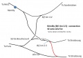
Image:North of Angouleme.png|LGV Sud-Ouest - connections north of Angoulême | |||
Image:Nimes junctions.jpg|Lines east of Nimes | Image:Nimes junctions.jpg|Lines east of Nimes | ||
</gallery> | </gallery> | ||
==Germany== | ==Germany== | ||
<gallery> | <gallery> | ||
Image:Aachen.png|Aachen | Image:Aachen.png|Aachen | ||
| Line 174: | Line 182: | ||
==Hungary== | ==Hungary== | ||
<gallery> | <gallery> | ||
Image:Budapest_1.png|Budapest part 1 | Image:Budapest_1.png|Budapest part 1 | ||
| Line 182: | Line 189: | ||
Image:Szolnok.png|Szolnok | Image:Szolnok.png|Szolnok | ||
</gallery> | </gallery> | ||
==Israel== | |||
See [https://www.egtrow.info/wiki/Israel_-_Maps_and_Plans EGTROW] | |||
<!-- | |||
<gallery> | |||
Image:Israel.png | |||
</gallery> | |||
--> | |||
==Italy== | ==Italy== | ||
<gallery> | <gallery> | ||
Image:Milano1.pdf|Milano1 | Image:Milano1.pdf|Milano1 | ||
| Line 192: | Line 206: | ||
Image:Roma.png|Roma | Image:Roma.png|Roma | ||
Image:Vatican.png|Vatican City | Image:Vatican.png|Vatican City | ||
</gallery> | </gallery> | ||
| Line 205: | Line 214: | ||
==Netherlands== | ==Netherlands== | ||
<gallery> | <gallery> | ||
Image:Utrecht Overvecht.jpg|Utrecht Overvecht area | Image:Utrecht Overvecht.jpg|Utrecht Overvecht area | ||
| Line 211: | Line 219: | ||
==Norway== | ==Norway== | ||
<gallery> | <gallery> | ||
Image: Lillestrom.jpg | Lillestrøm - connections to the west | Image: Lillestrom.jpg | Lillestrøm - connections to the west | ||
Image: Oslo_1.jpg | Romeriksporten Tunnel area and Oslo Sentral | Image: Oslo_1.jpg | Romeriksporten Tunnel area and Oslo Sentral | ||
Image: Ski_Northern_Approaches.png | The Northern approaches to Ski | |||
Image: Oslo_Southern_Approaches.png | Oslo Sentral southern approaches from the Ski line | |||
Image:Oslo Lufthavn.png|Routes to Oslo airport | Image:Oslo Lufthavn.png|Routes to Oslo airport | ||
Image:NSB_Tonsberg_Realignment.png|Tonsberg | Image:NSB_Tonsberg_Realignment.png|Tonsberg | ||
| Line 220: | Line 229: | ||
==Poland== | ==Poland== | ||
<gallery> | <gallery> | ||
Image:Coal trunk Line Master.png|The north - south Coal Trunk Line (Magistrala węglowa) | Image:Coal trunk Line Master.png|The north - south Coal Trunk Line (Magistrala węglowa) | ||
| Line 252: | Line 260: | ||
==Portugal== | ==Portugal== | ||
<gallery> | <gallery> | ||
Image:Alcácer do Sal avoiding line.gif|Alcácer do Sal avoiding line.gif | Image:Alcácer do Sal avoiding line.gif|Alcácer do Sal avoiding line.gif | ||
| Line 258: | Line 265: | ||
==Romania== | ==Romania== | ||
<gallery> | <gallery> | ||
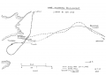
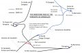
Image:Bucharest1.jpg|Bucharest area, showing one of the unusual routes used in the area | Image:Bucharest1.jpg|Bucharest area, showing one of the unusual routes used in the area | ||
| Line 266: | Line 272: | ||
==Serbia== | ==Serbia== | ||
<gallery> | <gallery> | ||
Image:Beograd North.png|Beograd North as at July 2020 | Image:Beograd North.png|Beograd North as at July 2020 | ||
| Line 275: | Line 280: | ||
==Slovakia== | ==Slovakia== | ||
<gallery> | <gallery> | ||
Image:Bratislava.png|Bratislava | Image:Bratislava.png|Bratislava | ||
| Line 286: | Line 290: | ||
==Slovenia== | ==Slovenia== | ||
<gallery> | <gallery> | ||
Image:Ljubljana.png|Ljubljana | Image:Ljubljana.png|Ljubljana | ||
| Line 292: | Line 295: | ||
==Spain== | ==Spain== | ||
<gallery> | <gallery> | ||
Image:Leon.png|León area as at April 2022 | Image:Leon.png|León area as at April 2022 | ||
| Line 298: | Line 300: | ||
Galicia & Leon LAV Map 2.jpg|Diagrammatic map of LAV and associated lines in the area of Galicia & Leon as at January 2016 | Galicia & Leon LAV Map 2.jpg|Diagrammatic map of LAV and associated lines in the area of Galicia & Leon as at January 2016 | ||
Image:Castellbisbal.jpg|Castellbisbal | Image:Castellbisbal.jpg|Castellbisbal | ||
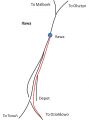
Image:Las Rozas.jpg|Las Rozas triangle | Image:Las Rozas.jpg|Las Rozas triangle north-west of Madrid | ||
Image:Valencia Area. | Image:Valencia Area.png|València Area, showing obscure routes | ||
Image: | Image:Xàtiva – La Encina.png|'''Xàtiva – Moixent – La Encina''' showing future high speed line route | ||
Image:La Encina.jpg|La Encina area as at September 2023 | |||
Image:Vandellos.jpg|Eastern end of the Variante de Vandellós | Image:Vandellos.jpg|Eastern end of the Variante de Vandellós | ||
Image:Palencia.png|Palencia and Venta de Baños area | |||
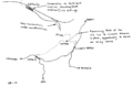
Image:Plasencia.png|Plasencia and Cáceres area | |||
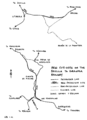
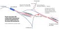
Image:Espeluy.png|Historical map of the '''Espeluy - Linares''' area of Andalucia in 2000 | Image:Espeluy.png|Historical map of the '''Espeluy - Linares''' area of Andalucia in 2000 | ||
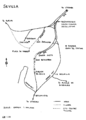
Image:Sevilla_area.jpg|Sevilla area as at February 2020, showing obscure routes | Image:Sevilla_area.jpg|Sevilla area as at February 2020, showing obscure routes | ||
Image:Antequera. | Image:Antequera.png|Layout and obscure routes in the Antequera Santa Ana area | ||
Image:Andalucia.png|Historical map of the '''Sevilla - Granada''' line through Andalucia, showing 1990s cut-offs or ''Variantes'' | Image:Andalucia.png|Historical map of the '''Sevilla - Granada''' line through Andalucia, showing 1990s cut-offs or ''Variantes'' | ||
Image:Sevilla.png|Historical map of Sevilla 2001 | Image:Sevilla.png|Historical map of Sevilla 2001 | ||
| Line 310: | Line 315: | ||
==Sweden== | ==Sweden== | ||
<gallery> | <gallery> | ||
Image:Ange4.jpg|Bollnäs (Ovansjö) – Bräcke (Moradal) (via Ångebyn) | Image:Ange4.jpg|Bollnäs (Ovansjö) – Bräcke (Moradal) (via Ångebyn) | ||
Image:Malmo.jpg|Malmö | Image:Malmo.jpg|Malmö | ||
| Line 328: | Line 331: | ||
==Tunisia== | ==Tunisia== | ||
See [https://www.egtrow.info/wiki/Tunisia_-_Maps_and_Plans EGTROW] | |||
<!-- | |||
<gallery> | <gallery> | ||
Image:Tunis.png|Tunis | Image:Tunis.png|Tunis | ||
Image:SNCFT_Map.jpg|SNCFT System Map | Image:SNCFT_Map.jpg|SNCFT System Map | ||
</gallery> | </gallery> | ||
--> | |||
==Turkey== | ==Turkey== | ||
<gallery> | <gallery> | ||
Image:Kutahya and Alayunt area 3.jpg|Kutahya and Alayunt area | Image:Kutahya and Alayunt area 3.jpg|Kutahya and Alayunt area | ||
| Line 345: | Line 349: | ||
==Ukraine== | ==Ukraine== | ||
<gallery> | <gallery> | ||
Image:Fastiv.jpg|Fastiv | Image:Fastiv.jpg|Fastiv | ||
Latest revision as of 16:15, 3 April 2024
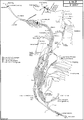
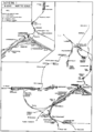
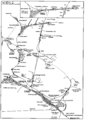
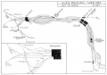
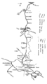
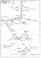
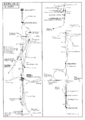
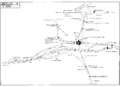
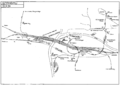
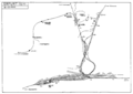
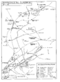
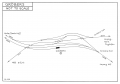
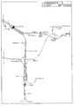
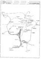
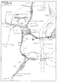
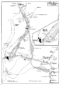
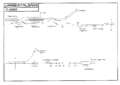
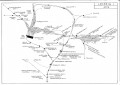
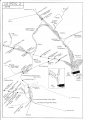
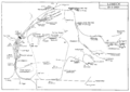
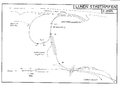
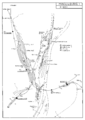
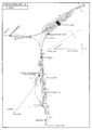
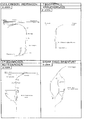
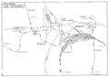
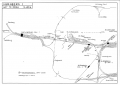
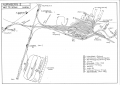
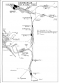
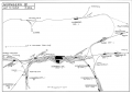
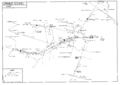
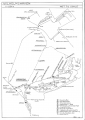
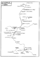
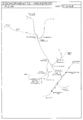
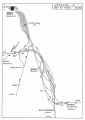
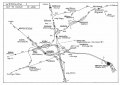
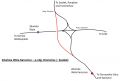
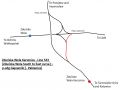
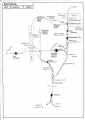
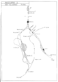
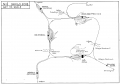
Railway Maps and Plans - Europe
Many of the railway layout maps and plans on this page were drawn by Rodger Wilkinson of Chester-le-Street and Gregory Beecroft of Welwyn Garden City. These maps were formerly hosted on the 'Rinbad' website, but have been moved with permission.
You may access the maps and print them for personal use, but must not use them for any purpose involving resale. You may have more control of how your printer fits a map on to a paper page if you Save As File and print from another program such as Microsoft Photo Editor rather than printing direct from your browser.
Please remember that the maps were current at the dates when they were created but may have been overtaken by subsequent events.
Maps and plans for countries beyond Europe are now held at the Enthusiast's Guide to Travelling the Railways of the Rest of the World - see the relevant EGTROW page
Australia
See EGTROW
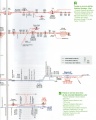
Austria
-
Linz
-
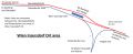
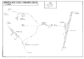
Wien (west) as at May 2001
-
Wien (east) as at May 2001
-
Wien-Meidling / Wien Hbf as at October 2017
-
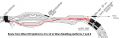
Wien Matzleinsdorfer Platz – Wien Hauptbahnhof (platforms 3 and 4)
-
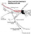
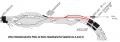
Direct route from Speising to Meidling North Side
-
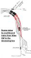
Wien Meidling – Wien Hauptbahnhof (platforms 4 to 12)
-
Wien Hauptbahnhof – Wien Simmering
-
Wien Inzersdorf Ort
-
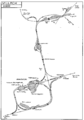
Kledering area
-
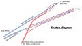
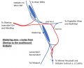
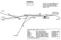
Knoten Wagram, showing the Güterzugumfahrung St. Pölten
-
Villach
-
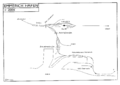
Internationale Rheinregulierungsbahn


Belarus
-
Minsk
-
Orsha


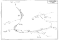
Belgium
-
Area south of Berchem
-
Mechelen Area, showing Lines 25 & 27 north and south.
-
Brussels North
-
Brussels South
-
Gent-Sint-Pieters - Drongen (Y Assels)
-
Tongeren - Visé Haut - Montzen - Aachen (Germany)
-
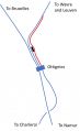
Ottignies
-
Saint-Ghislain
-
Tongeren - Visé Haut - Montzen - Aachen (Germany)


Bosnia-Herzegovina
-
Sarajevo
-
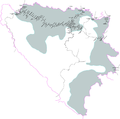
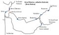
Republika Srpska
-
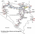
Bosnia 2
-
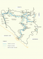
Bosnia 3


Bulgaria
-
Sofia East
-
Sofia West


Croatia
-
Pula
-
Zagreb


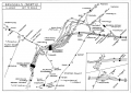
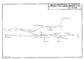
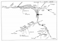
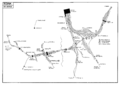
Czech Republic
-

Bohumin area
-
Brno as at July 2017
-
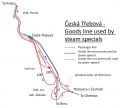
Česká Třebová goods lines
-
Brno-Židenice – odbočka Slatinská
-
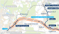
Ejpovice Tunnel Diversion
-
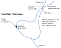
Havlickuv Brod
-
Liberec
-
Most-Kopisty showing unusual route
-
Praha 1
-

Praha 1 showing revised layout to the east of Praha hl.n. and Masarykovo n.
-
Praha 2


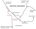
Denmark
-
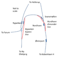
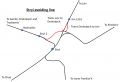
Nordhavn
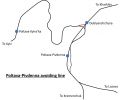
-
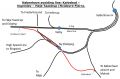
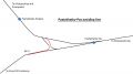
København avoiding line
-
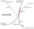
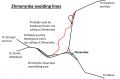
Køge Nord to Ølby


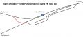
France
-

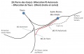
LGV Nord diagramatic map
-

LGV Est diagramatic map
-
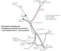
Lille Flandres avoiding line - Raccordement de Becquerel
-
LGV Est - Raccordement de Lucy
-

Sarrebourg avoiding line
-

Sarrebourg Area
-
LGV Sud-Est - Raccordement de Valenton
-
LGV Sud-Ouest - Massy TGV
-

LGV Bretagne-Pays de la Loire - Sablé-sur-Sarthe Triangle
-
Dijon
-
Tours & St Pierre des Corps
-
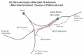
Tours & St Pierre des Corps
-

Culoz
-
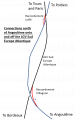
LGV Sud-Ouest - connections north of Angoulême
-
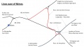
Lines east of Nimes


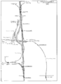
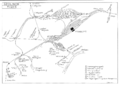
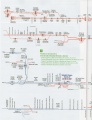
Germany
-
Aachen
-
Amstetten (Württ.)
-
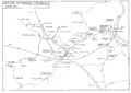
Bad Muskau area near Polish border, including Waldeisenbahn and local mineral-line connections
-
Berlin 1 (Jungfernheide - Lehrter Bahnhof)
-
Berlin 2 (Treptow - Neukölln - Schönefeld)
-
Berlin 3 (Hauptbahnhof - Südkreuz - Ludwigsfeld)
-
Berlin 4 (Charlottenburg - Westkreuz - Grunewald)
-
Spandau area of Berlin
-
Bitterfeld
-
Braunschweig
-
Bremen 1 (west)
-
Bremen 2 (east)
-
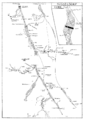
Cottbus, showing arrangement of platforms and accessibility from converging routes
-
Düsseldorf
-
Emden
-
Emmerich Hafen
-
Erfurt
-
Gladbeck - Ruhrkohle AG system
-
Junction at Gröbers on Erfurt to Leipzig NBS
-

Hannover 1 (west)
-
Hannover 2 (east and south)
-
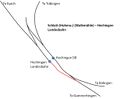
Hechingen
-
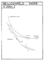
Heiligenfeld, Horb
-
Ingolstadt
-
Kassel
-
Kiel
-
Köln 1 (west - Hauptbahnhof and Eifeltor)
-
Köln 2 (east - Deutz and Gremberg)
-
Laabertalbahn (Eggmühl - Langquaid)
-
Leipzig East Side
-
Leipzig West Side
-
Lübeck
-
Lünen Süd: Stadthafen
-
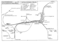
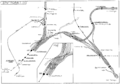
Magdeburg 1
-
Magdeburg 2
-
Meitingen: SGL Carbon, Krauchenwies: Tegomettall, Rottenacker: Fa.Bohnacker, Baienfurt: Stora Enso
-
Minden
-
Bahnen der Stadt Monheim
-
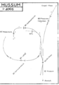
Mussum
-
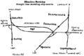
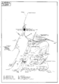
München, showing connections to the Nordring freight line
-
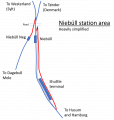
Niebüll, showing possible unusual route for Sylt Shuttle
-
Nürnberg 1 (North West)
-
Nürnberg 2 (South West)
-
Nürnberg 3 (South East)
-
Nürnberg 4 (North East)
-
Oldenburg
-
Osnabrück
-
Piesberg-Osnabrück
-
Regensburg
-
Rheinhausen Ost: Logport
-
Saarbrücken
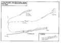
-
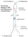
Sandersleben
-
Spandau area of Berlin
-
Stuttgart 1 (Hauptbahnhof - Untertürkheim)
-
Stuttgart 2 (Zuffenhausen - Ludwigsburg)
-
Ulm
-
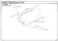
Unna: Industriepark
-
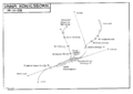
Unna Königsborn
-
Wanne Eickel
-
Wilhelmshaven
-
Wismutbahn
-
Zschornewitz-Vockerode, the brown-coal mining area near Dessau


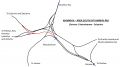
.png)


Hungary
-
Budapest part 1
-
Budapest part 2
-
Budapest part 3
-
Eger
-
Szolnok


Israel
See EGTROW
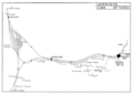
Italy
-

Milano1
-
Milano2
-
Napoli
-
Napoli with new HSL triangle
-
Roma
-
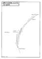
Vatican City


Lithuania
-
Vaidotai

Netherlands
-
Utrecht Overvecht area

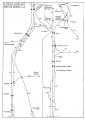
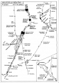
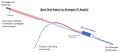
Norway
-
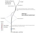
Lillestrøm - connections to the west
-
Romeriksporten Tunnel area and Oslo Sentral
-
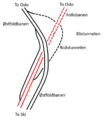
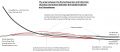
The Northern approaches to Ski
-
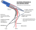
Oslo Sentral southern approaches from the Ski line
-
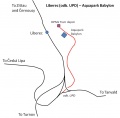
Routes to Oslo airport
-
Tonsberg


Poland
-
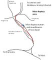
The north - south Coal Trunk Line (Magistrala węglowa)
-

Czerwiensk
-
Gdynia
-
Iława
-
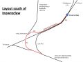
Inowroclaw
-
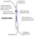
Jarocin
-
Kedzierzyn Kozle avoiding line
-
Kedzierzyn Kozle line 151
-
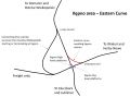
Kepno Eastern Curve
-
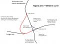
Kepno Western Curve
-
Koluszki
-
Lazy
-
Piła
-
Poznan
-

Gdynia - Rumia area
-

Rzepin
-
Szczecin
-
Szczecin western approaches
-
Szczecin Podjucy - Szczecin Zdroje
-
Tczew
-
East of Warszawa Wschodnia map 1
-
East of Warszawa Wschodnia map 2
-
Wrocław East
-
Wrocław West
-

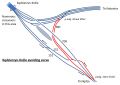
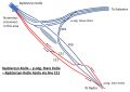
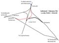
Zduńska Wola north east curve
-
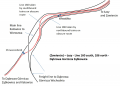
North - South line avoiding Zduńska Wola
-
Zduńska Wola south east curve


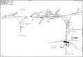
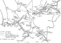
Portugal
-
Alcácer do Sal avoiding line.gif

Romania
-
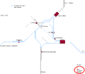
Bucharest area, showing one of the unusual routes used in the area
-
Lunca Budieni - Copacioasa 'double track' section
-
Constanţa


Serbia
-
Beograd North as at July 2020
-
Beograd South as at July 2016
-
Ћуприја / Ćuprija
-
Niš


_deviation.jpg)

Slovakia
-
Bratislava
-
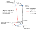
Bratislava Rail Routes Diagram
-
Košice
-
Vrútky
-
Žilina 1
-
Žilina 2


Slovenia
-
Ljubljana

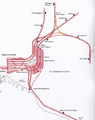
Spain
-
León area as at April 2022
-
Diagrammatic map of LAV and associated lines in the area of Galicia & Leon as at January 2016
-
Diagrammatic map of LAV and associated lines in the area of Galicia & Leon as at January 2016
-
Castellbisbal
-
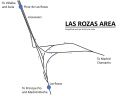
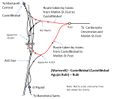
Las Rozas triangle north-west of Madrid
-
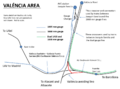
València Area, showing obscure routes
-
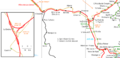
Xàtiva – Moixent – La Encina showing future high speed line route
-
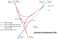
La Encina area as at September 2023
-
Eastern end of the Variante de Vandellós
-
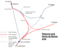
Palencia and Venta de Baños area
-

Plasencia and Cáceres area
-
Historical map of the Espeluy - Linares area of Andalucia in 2000
-
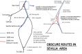
Sevilla area as at February 2020, showing obscure routes
-

Layout and obscure routes in the Antequera Santa Ana area
-
Historical map of the Sevilla - Granada line through Andalucia, showing 1990s cut-offs or Variantes
-
Historical map of Sevilla 2001


Sweden
-
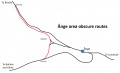
Bollnäs (Ovansjö) – Bräcke (Moradal) (via Ångebyn)
-
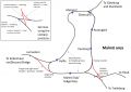
Malmö


Switzerland
-
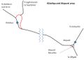
Basel area
-
Eppenburg Tunnel
-
Internationale Rheinregulierungsbahn
-
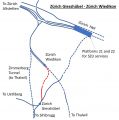
Zürich Giesshübel - Zürich Wiedikon.
-

Kerzers
-
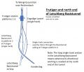
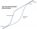
Frutigen


Tunisia
See EGTROW
Turkey
-
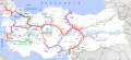
Kutahya and Alayunt area
-
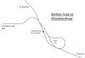
Afyonkarahisar
-
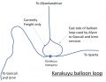
Karakuyu
-
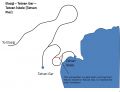
Tatvan Gar – Tatvan İskele
-
Type of signalling on each line


Ukraine
-
Fastiv
-
Kharkiv
-
(Kharkiv-Pas.-) z.p. Novoselivka - Zalyutine
-
(Kharkiv-Pas. -) or west of city to rzd. 6 km - Osnova
-
Kharkiv: area south of Kharkiv-Pas
-
Korosten’
-
Odesa
-
Poltava
-
Pyatykhatky
-
Stryi
-
Zhmerynka

_z.p._Novoselivka_-_Zalyutine.jpg)
_or_west_of_city_to_rzd._6_km_-_Osnova.jpg)
_Novozhanove_-_Zalyutine.jpg)


